

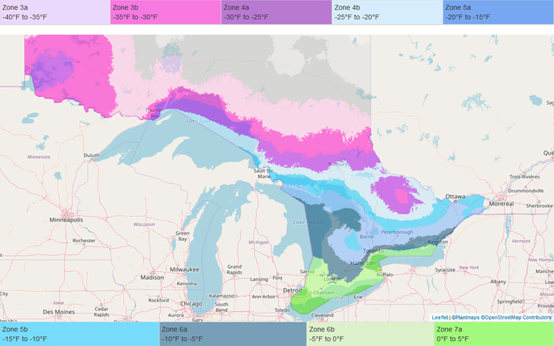
Hardiness zones are based on the average annual extreme minimum temperature during a 30-year period in the past, not the lowest temperature that has ever occurred in the past or might occur in the future.
Plant hardines zone maps are just guides. They are based on the average lowest temperatures, not the lowest ever. Gardeners should keep that in mind when selecting plants, especially if they choose to "push" their hardiness zone by growing plants not rated for their zone. Also, keep in mind that there might still be microclimates that are too small to show up on the hardiness zone map.
Microclimates, which are fine-scale climate variations, can be small heat islands (such as those caused by blacktop and concrete) or cool spots caused by small hills and valleys. Individual gardens also may have very localized microclimates. Your entire yard could be somewhat warmer or cooler than the surrounding area because it is sheltered or exposed. You also could have pockets within your garden that are warmer or cooler than the general zone for your area or for the rest of your yard, such as a sheltered area in front of a south-facing wall or a low spot where cold air pools first. No hardiness zone map can take the place of the detailed knowledge that gardeners pick up about their own gardens through hands-on experience.
Growing plants at the extreme of the coldest zone where they are adapted means that they could experience a year with a rare, extreme cold snap that lasts just a day or two, and plants that have thrived happily for several years could be lost. Gardeners need to keep that in mind and understand that past weather records cannot be a guarantee for future variation in weather.
Many other environmental factors, in addition to hardiness zones, contribute to the success or failure of plants. Find out more about other Environmental Factors Affecting Survival of Plants.